Scientists use technology to develop first-ever, Caribbean-wide benthic habitat maps
Despite coral reef’s rich contributions to people and marine life, scientists estimate that the Caribbean has lost 60 percent of its healthy coral in the past three decades. Conservation and restoration programs have been partly challenged by the lack of detailed maps of the region’s coral reefs and benthic habitats. An environmental nonprofit aims to help by using an eCognition-based mapping technique to create the first-ever, high-resolution benthic habitat maps of the Caribbean basin.
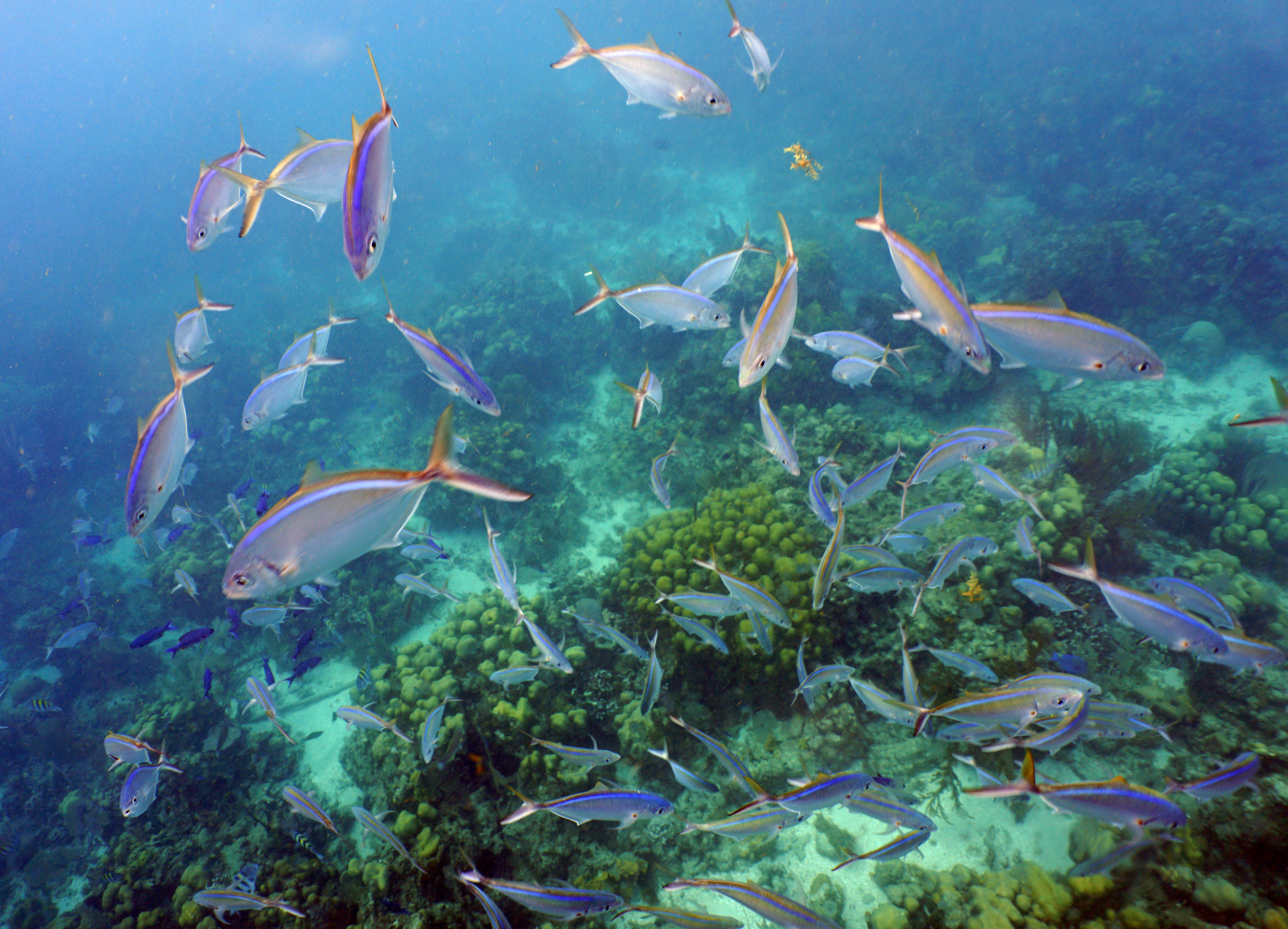 A school of Bar Jacks swim above Boulder Star Coral just off Isla Catalina in the Dominican Republic.
The Caribbean Division of The Nature Conservancy (TNC) has been focused on monitoring, protecting and restoring the region’s marine environments for more than 40 years. As the plight of coral reefs has become more urgent, so too have TNC’s efforts to tackle coral conservation––and meet the demands for better maps.
“Reef maps are an essential tool for coral resource managers, but historically these maps have had insufficient detail, been outdated or been produced for small areas,” said Dr. Steve Schill, TNC’s lead scientist and marine conservation specialist in the Caribbean Division. “Not having access to accurate, large-area reef maps has limited our understanding of these ecosystems and the benefits they provide.”
Having used eCognition object-based image analysis (OBIA) software for automatically classifying and mapping small reef areas, Schill believed eCognition could be the enabling, scalable approach to map the hundreds of thousands of reefs across the region. eCognition is made by Trimble.
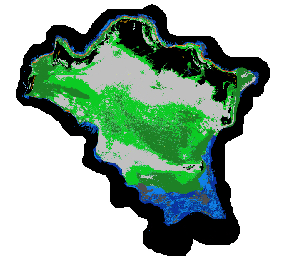 An eCognition classification of 14 different benthic habitats for Turks and Caicos.
To begin, Schill worked with technical professionals at Earth observation company Planet and researchers at Arizona State University (ASU) to select more than 30,000 4-meter-resolution scenes from the Dove satellite constellation. The team then created a seamless mosaic of the whole Caribbean basin. He also partnered with eCognition specialists Tama Group to develop the OBIA method to automatically classify benthic habitats.
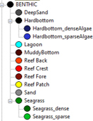
To map reefs, Tama Group experts integrated the Dove satellite surface reflectance and Dove-derived bathymetry into eCognition. The software first delineates land and sea areas deeper than 15 m. Based on depth data and known topographic characteristics, it then categorizes the overall reef structure, distinguishing reef crest, fore reef, back reef, patch and fringing reef. Once it defines the five reef classes, eCognition determines seagrass classes (dense and sparse), sand types, dredged areas, and then finishes with mapping the deeper hard bottom algae classes. In total, the software automatically classifies 13 different benthic habitats.
“This software is smart,” said Ralph Humberg, Tama Group’s managing director. “It takes in all this information we give it about coral reefs and uses it in the context of pixel characteristics and spatial relationships to classify features. It knows where features should and shouldn’t exist. That’s why it can accurately classify objects that look similar, like seagrass and hard bottom with algae.”
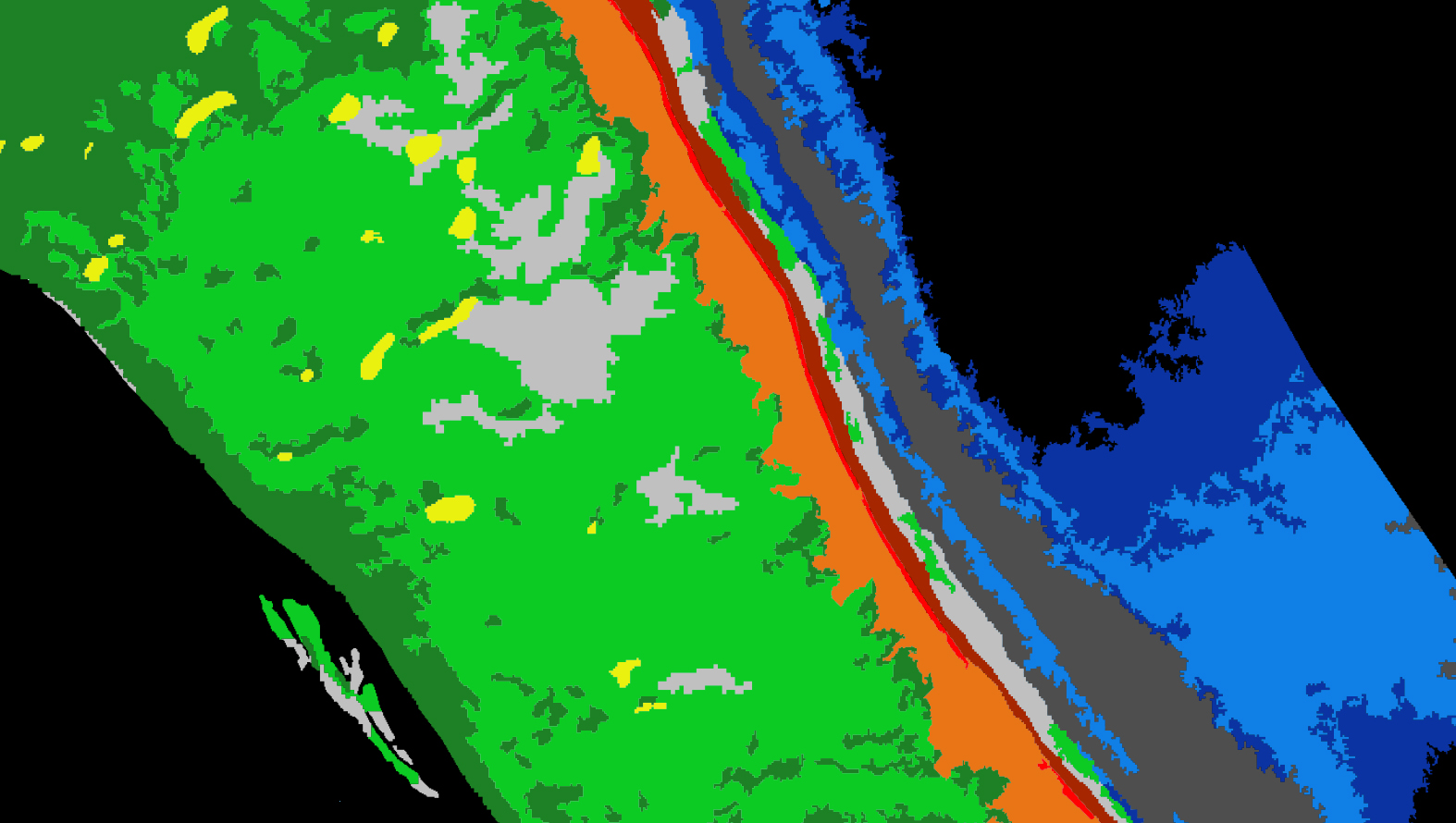 An eCognition classification of 14 different benthic habitats for Turks and Caicos.
Using this workflow, the software successfully classified the shallow water benthic habitats of the entire Caribbean Basin in four months –– an area about the size of Texas and California combined. The software exported each classified area as vector shapefiles and Schill and his team downloaded them for analysis and quality control.
With each classification, Schill’s team has been assessing the data to map the benthic habitats. Moving from reef to reef, they’ve been using field data to methodically analyze the accuracy of the classifications, and making manual corrections where needed.
 An eCognition classification of 14 different benthic habitats for Turks and Caicos.
To date, benthic habitat maps have been produced for 23 countries and territories across the insular Caribbean and are being reviewed for accuracy and quality control. In October 2020, the final full set of benthic habitat maps for the insular Caribbean will be viewable and downloadable online. The maps will also be available on the Allen Coral Atlas’ online atlas.
“Combining eCognition with Dove imagery has made mapping at this scale possible,” said Schill. “We’ve never before been able to map such large areas at such detail. With these high resolution coral reef maps, resource managers can better understand the benefits these habitats provide to people and develop strategic conservation actions.
“It’s a new era for marine mapping.”
By Mary Jo Wagner