By: Steve G. Buschang, Director of Research and Development, State Scientific Support Coordinator, Texas General Land Office, Oil Spill Prevention and Response Program
Someone once said, “Adventure is just bad planning.”
Most of us in the spill response community already experience enough adventure. So we plan, and then revise those plans. Whether it be industry personnel planning the movement of a rig to a location to begin drilling in 8,000 ft of water, or state and federal wildlife refuge managers devising protection plans for a nearly extinct species, or federal agencies and/or state agencies planning for catastrophic events on a more regional level, we contrive scenarios based on our amassed knowledge from science and experience with countless past spills and exercises into what we hope will aid us in the next “BIG” event.
Background
Oil spills can devastate environmental resources, economies, and entire ecosystems. So, with a state that has 3 of the top 10 busiest ports in the nation, 3,300 mi of jurisdictional shoreline, and 426 mi of Intracoastal Waterway transporting oil, fuel, and cargo the length of the state, Texas has a vested interest in protecting its valuable natural resources. Notably, Texas is one of just four states with a dedicated oil spill prevention and response program. The Texas General Land Office (TGLO) Oil Spill program was created after a series of events in the late 1980s, including the 1989 grounding of the tanker Exxon Valdez, which ran aground on Bligh Reef in Prince William Sound, Alaska, releasing approximately 10.9 million gallons of Alaskan North Slope crude oil into the pristine waters of the Sound. In June 1990, the tank vessel Mega Borg released some 4.6 million gallons of light Angolan crude into the Gulf of Mexico. Later that same year, two Apex barges were struck in the Houston Ship Channel, releasing 700,000 gallons of catalytic feedstock oil. These events prompted the Texas Legislature to pass the Oil Spill Prevention and Response Act of 1991 (OSPRA), which designated the TGLO as the lead state agency for coastal oil spill prevention and response.
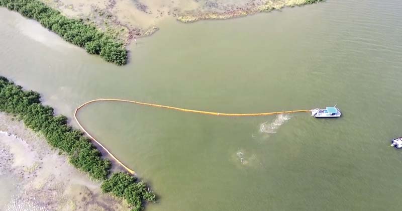
Black Mangrove & Saltwater Marsh area - TGLO response personnel exercising GRP booming protection plan strategies. This location would have an ESI 10A/10D ratings.
Photo credit: (Drone Image) by S. Buschang.
OSPRA conveyed to the TGLO spill response jurisdiction for all tidally influenced waters extending from the head of tide in the arms of the Gulf of Mexico seaward out to three marine leagues as well as for the non-tidally influenced waters extending from the head of tide inland to where navigation by regulated vessels is naturally or artificially obstructed. OSPRA mandated, among other duties, the responsibility for the TGLO to “prevent spills and discharges of oil by requiring and monitoring preventive measures and response planning.”
To prepare the state for potential oil spills, the TGLO initiated a number of measures. Administrative rules detailed how the TGLO would fulfill this new obligation, as embodied in Title 31, Chapters 19 and 20 of the Texas Administrative Code.
OSPRA required that all waterfront oil handling facilities and certain classes of vessels are to be covered by a state discharge prevention and response certificate and to have a readily accessible oil spill contingency plan. Certified facilities would be subject to annual audits and inspections and be required to provide storage and containment data, including 24-hr contact information. For the first time, facilities would be required to pre-identify certified discharge cleanup organizations (DCOs), thereby assuring the state that the facility has the capability to respond. The law established a certification program for cleanup contractors wishing to become certified DCOs.
Impacts to Smooth Cordgrass Marsh - Impacts resulted from release of some 189,000 gallons of oil during a heavy weather event impacting saltwater marsh and other shoreline habitat. Valero/Citgo Spill, Corpus Christi Inner Harbor, June 2006. Sensitivity Rating: ESI 10A. Internal documentation and nrt.sraprod.com/nrtconf/reports/2006/RRT%206%20annual%20report.pdf.
Field offices were established in five strategic locations along the coastal zone, staffed with qualified response officers who respond 24/7 to spills reported to a newly established statewide spill hotline. Over 30 response personnel are on staff to enforce the full slate of oil spill regulations.
Toolkit
Early in the implementation phase of OSPRA, response personnel noted that a tool containing pre-planning documents and resources would be invaluable. Although some facilities would collect information about a geographic area, there was no comprehensive source that could be utilized by all. Area committee plans had been established by the Oil Pollution Act of 1990 (OPA 90) describing strategies for a coordinated federal, state, and local response within the Captain of the Port Zone (COPT) to respond to oil and hazardous substances. This planning included the identification of sensitive areas, protection priorities, and protection methods. However, these original documents were often more general in nature, detailing procedures rather than comprehensive guidance and site-specific information.
Recognizing these deficiencies, the TGLO assembled the first Texas Coastal Oil Spill Planning & Response CD "Toolkit" in 1999. At the onset, the TGLO realized that a spill response tool should not just include the State of Texas, as oil spills in the Gulf of Mexico (GOM) do not respect such boundaries. The Toolkit includes plans and documents for the entire Gulf of Mexico—from the U.S./Mexican border to the Panhandle of Florida—following boundaries established in the National Contingency Plan (NCP) and representing the coastal zone of the Regional Response Team (RRT) VI. Early on, existing spill response documents were incorporated into the Toolkit, including the existing Area Committee Plans already developed for each U.S. Coast Guard Captain of the Port zone. An effort was undertaken to identify all existing vulnerable natural resources as well as socioeconomic and human-use features such as water intakes, boat ramps, access points, and heliports. The Toolkit includes other maps, tools, and documents such as stakeholder maps, Priority Protection Areas (PPAs), alternative technology pre-approval maps, Regional Response Team (RRT) documents, site-specific response plans, job aids and manuals, and numerous useful planning and response-related internet links—all compiled in a single response tool.
ESI Atlas One of the most important components of the Oil Spill Toolkit is the coastal Environmental Sensitivity Index (ESI) and Habitat Priority mapping atlas. Closely following the schema of existing ESI mapping projects being developed in other regions of the U.S., the TGLO undertook the task of acquiring known habitat, biological, and human-use (socioeconomic) data and the identifying, typing, and mapping of all shorelines along the Texas coast. Interestingly, the first ESI project in the U.S. began in Texas in 1979 when the Ixtoc I well blew out in Mexico's Bay of Campeche. Oil migrated north to the shores of Texas following northerly Gulf of Mexico currents and ultimately resulted in some 161 mi of shoreline oiled with over 3,000,000 million gallons of heavy crude.
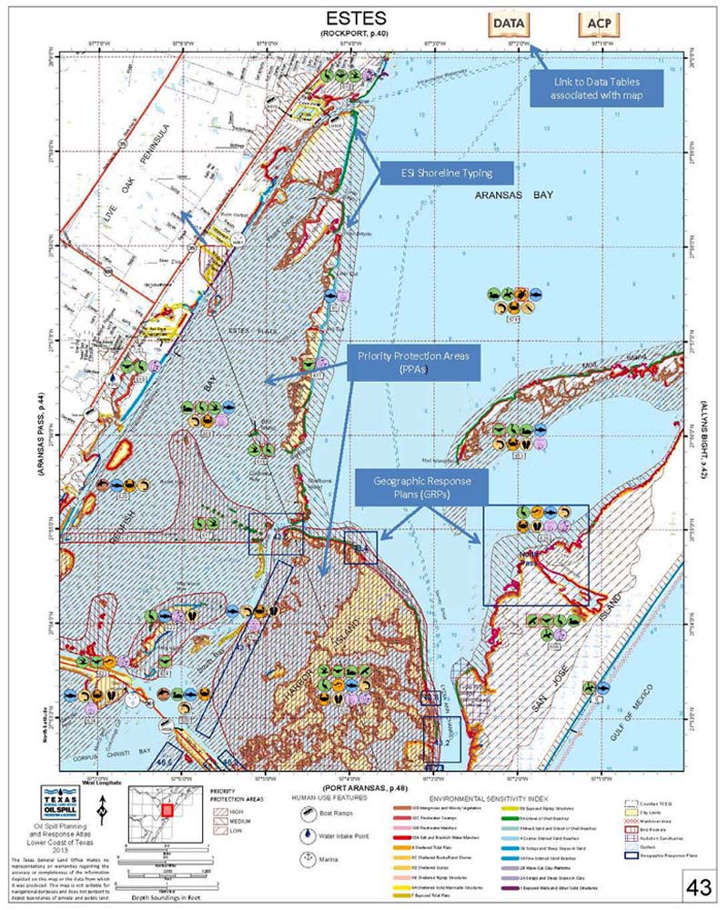
TGLO Atlas Map displaying ESI shoreline types, biological resources, PPAs, GRPs and human use features found in this area. Biological resources at risk accessible through provided link top right.
Texas' current shoreline typing now follows established convention utilizing a process that ranks shoreline environments by their sensitivity to oil spills. This uniform methodology allows for response personnel such as the USCG and outside contractors that may not be familiar with the local area to have a common operating picture (COP) to aid in response implementation. ESI typing consists of ranking shorelines on a scale of 1 to 10, with higher numbers identifying the most sensitive habitats such as bottom land hardwoods, mangroves, and marshes. Lower numbers identify less sensitive shorelines such as rip-rap and concrete bulkheads. The primary use of ESI is to help to prioritize the allocation and placement of often limited resources. Since 1995, over 3,000 linear miles of the Texas shoreline has twice been typed. Importantly, a single shoreline can be depicted with up to three different shoreline types in areas where, often, different sensitivities exist laterally landward from water.
Other component layers of the ESI Atlas consist of biological and socioeconomic layer data sets.
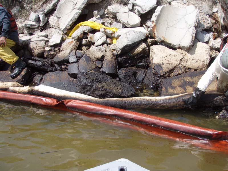
Impacts to rip-rap shoreline - Impacts resulted from release of some 189,000 gallons of oil during a heavy weather event impacting saltwater marsh and other shoreline habitat. Corpus Christi Inner Harbor, June 2006. Sensitivity rating: ESI 1. (nrt.sraprod.com/nrtconf/reports/2006/RRT%206%20annual%20report.pdf).
The biological data sets are built from a number of differing sources. For Texas, existing data sets and institutional knowledge are incorporated from their custodial entities such as the Texas Parks and Wildlife Department (TPWD), U.S. Departments of the Interior and Commerce, state and federal wildlife refuges and management areas, the Texas Nature Conservancy, the Audubon Society, and local commercial and recreational fisherman and birding groups, to name a few. Data were identified, and those species especially vulnerable to oils (i.e., those being identified as integral to the food web) or as being rare and listed as either a state or federal threatened or endangered species (T&E) are also included. Additionally, species exhibiting a unique locational susceptibility or abundance that may warrant recognition during a response action are also mapped, such as an area known to quarter large flocks of rafting waterfowl. These data are assigned a Resource at Risk Number (RARNUM) and are depicted geographically as a unique number and referenced as a listing in a data supplement on static atlas maps and geographic information system (GIS) platforms. Information on individual species may be found, including common name, scientific name, seasonality, life stages, T&E status and concern in the data table.
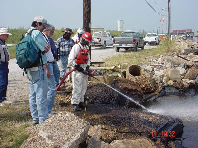
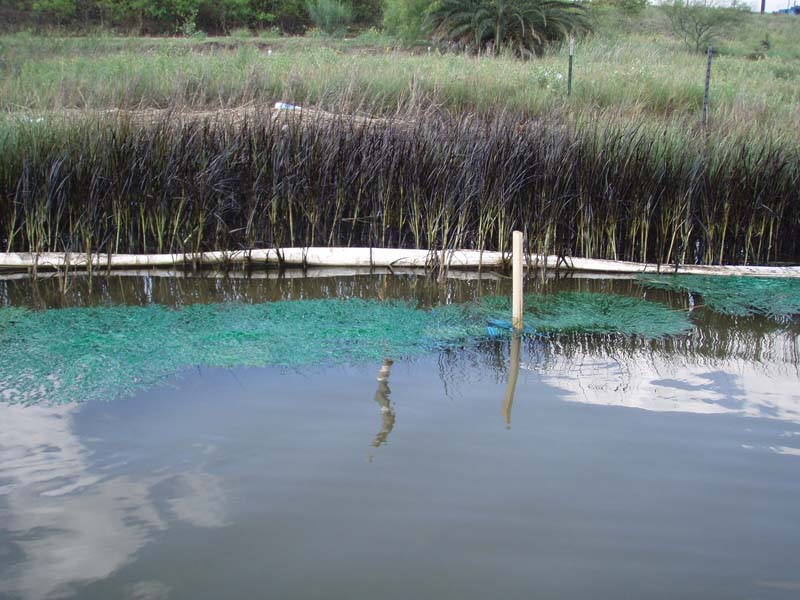
Shoreline oil contamination remediation utilizing approved surfacing washing agents monitored by NOAA and State of Texas Scientific Support Coordinators. Locatation: Corpus Christi Inner Harbor, June 2006. The TGLO atlas contains guidance, forms and RRT
pre-authorized locations for alternative cleanup measures expediting response operations. Internal Documentation and nrt.sraprod.com/nrtconf/reports/2006/RRT%206%20annual%20report.pdf
Socioeconomic layers containing human-use feature sets such as boat ramps, airports, heliports, water intakes, access points, and marinas are mapped and also displayed. Future plans include layers such as pre-identified staging and decontamination areas as well as stakeholder jurisdictions maps, beach mile markers, and political boundary maps.
PPAs and GRPs
Different than ESI Atlas data sets found in most other areas, Texas has developed additional coverage known as Priority Protection Areas (PPAs). Though much can be extracted from the RARNUM data, some localized areas often require more site-specific plans for spill protection due to the combination of localized environmental attributes, species makeup, and vulnerabilities to the short- and long-term impacts of oil. The PPA data sets were originally created in the mid 1990s for the entire Texas coast and were revised and updated again in 2014-2015. This data set identifies areas adjacent to coastal bays and the Gulf of Mexico containing sensitive coastal habitats or species to be protected from oil spill contamination or response activities. The PPAs were defined and digitized by TGLO personnel and contractors and were based on consultations with representatives of TPWD, other state and federal agencies, academic institutions, and private interest groups and citizens. Information from the PPAs can easily be extracted and incorporated into necessary planning documents used in the Incident Command System (ICS), namely the ICS 232-OS document “Resources at Risk Summary.”
Another data set that Texas has recently incorporated into the ESI base map layer is the Geographic Response Plans (GRPs). The GRPs provide first responders with extensive pertinent information regarding a specific location that can be quickly incorporated into an ICS spill response. Spill-specific information, such as atmospheric conditions, tidal cycles, and particular oil chemistry properties and behaviors can be added to the site-specific information so response personnel can deploy the appropriate equipment and have a complete picture of the incident. These plans are pre-housed in an ICS 204-CG “Assignment List” format for ease of inclusion into a response. Additionally, the GRPs include specific latitude/longitude coordinates, safety and weather considerations, water depth, response equipment recommendations, and tactical deployment guidance. Incident specific information is then easily included such as incident name, operational period, and operations personnel involved in the assignment.
GRPs are produced through each of the three Texas Area Committees, usually by assigned working groups, and vetted by the committees for incorporation into the respective ACP.
Other Toolkit Spill Response Resources
The Toolkit also houses other pertinent spill response and planning documents that are useful in an event. Geographic PDF (GEO-PDF) maps depict pre-approved and exclusionary areas for in-situ burning and dispersant use in the Gulf of Mexico. Related documents within the “Alternative Technologies” section lend guidance on these pre-approved areas and convey important details for implementing the particulars of the action. These resource documents detail the authorizations and processes necessary to implement such procedures during a response. Guidance is also given on the authorization and use of certain surface washing agents within pre-approved and defined areas. Detailed RRT guidance, flowcharts, and check sheets are included to expedite the processes.
Procedures and checklists on mandated consultations processes, such as those with state and federal historical and preservation agencies, are included when archaeological resources may be encountered during a spill event. Guidance, checklists, and procedures for requirements associated with T&E species consultation processes with the Departments of Interior and Commerce (both of which have jurisdiction on spill events that might impact T&E species) are also included. The availability and use of these documents in a single resource can greatly expedite the approval process for certain requested responses actions.
In 2004, Homeland Security Presidential Directive 5 (HSPD-5) called for a standardized approach to incident management among all federal, state, and local agencies. The National Incident Management System (NIMS), coupled with the already implemented Incident Command System, formed the response doctrine for all hazard responses. The Toolkit houses all of the ICS forms and the Incident Management Handbook to be used in emergency response.
The Toolkit has also become a clearinghouse for most of the Job Aids, manuals, guidelines, plans, and documents that may be applicable during a spill. Job Aids such as the NOAA Shoreline Assessment Job Aid for spill response, the Open Water Oil Identification Job Aid, and the Shoreline Countermeasures Manual are included and available for quick download and printing. Plans that detail how cross-boundary spill events with Mexico will be executed are included, as is the MEXUS treaty agreement. Plans and response procedures to natural disasters, as detailed in the Stafford Act (ESF10), are also available. Related forms, checklists, and protocols are offered for download and use.
Conclusion
Although administered, developed, and distributed by the TGLO, the Toolkit has become the premier response tool for state and federal response agencies and the oil handling industry. Each year 2,500 hard copy Toolkits are produced in DVD and Flash drive format and distributed free at venues such as the Clean Gulf Conference and Area Committee meetings as well as by request at www.glo.texas.gov/ost/toolkit- request/index.html. A downloadable version that is continually updated throughout the year is available online via the same link.
The focus of the Toolkit is simple: to better prepare for and expedite spill response efforts. Once oil has been spilled into the environment, urgent decisions need to be made quickly. The TGLO's goal was, and is, to gather all of the most important response resources available and put those resources in the hands of response professionals. The TGLO Toolkit will continue to bring important resources and tools together into one product so that impacts to the environment and socioeconomic infrastructure are minimized.