")
A robotic light sensor is helping Florida scientists and water managers train the eyes of satellites on algal blooms in some of the state’s iconic inland and coastal waterways.
The sensor is called the SeaPRISM, and it’s part of a field network of just 23 such stations across the world managed by NASA for validating data from ocean-observing satellites.
These tools were initially developed to help satellites measure vast quantities of phytoplankton across great swaths of the open ocean. But the satellites and the SeaPRISM network are increasingly important for researchers and managers of inland and coastal systems afflicted by harmful algal blooms like Lake Okeechobee and the Indian River Lagoon, both in Florida.
Images from the European Space Agency’s Sentinel-2 satellite show a bloom December 2020 at the site where Harbor Branch SeaPRISM is now installed. (Image credit: Tim Moore)
“We do now monitor Lake Okeechobee using satellites,” said James Sullivan, Executive Director of the Florida Atlantic University (FAU) Harbor Branch Oceanographic Institute and part of the team that brought the SeaPRISM to Florida waters. “It can help with that calibration validation that NASA does.”
The SeaPRISM station on Lake Okeechobee was one of just a few in the network observing an inland lake. The sensor has since moved to the Banana River, a section of the Indian River Lagoon estuary system with its own novel challenges for satellite observation.
Atmospheric Correction
The satellite sensors measure light at various wavelengths as it leaves the water’s surface. Experts relate the intensity of light at specific wavelengths to the abundance of certain species of tiny floating plants, which can be identified in their masses by their signature pigments.
While the satellite’s sky-high perspective makes it possible to measure large areas, that distance also comes with complications. Around 90% of the signal they capture comes from the atmosphere, which must be removed before scientists can trust that the data reflects the reality on the water. This is called atmospheric correction, and one resource this work depends on is the global SeaPRISM network.
“This instrument is basically doing the same thing as a satellite would do, but just right above the water instead of 500 miles in the sky,” said Timothy Moore, a Research Associate Professor at FAU Harbor Branch.
The SeaPRISM is a robotic radiometer that swivels toward the sun, sky, and water. Every 30 minutes, the device checks for a cloud-free view of the sun. If it’s clear, the sensor pivots downward and records a suite of optical measurements including aerosols in the air and the light leaving the water.
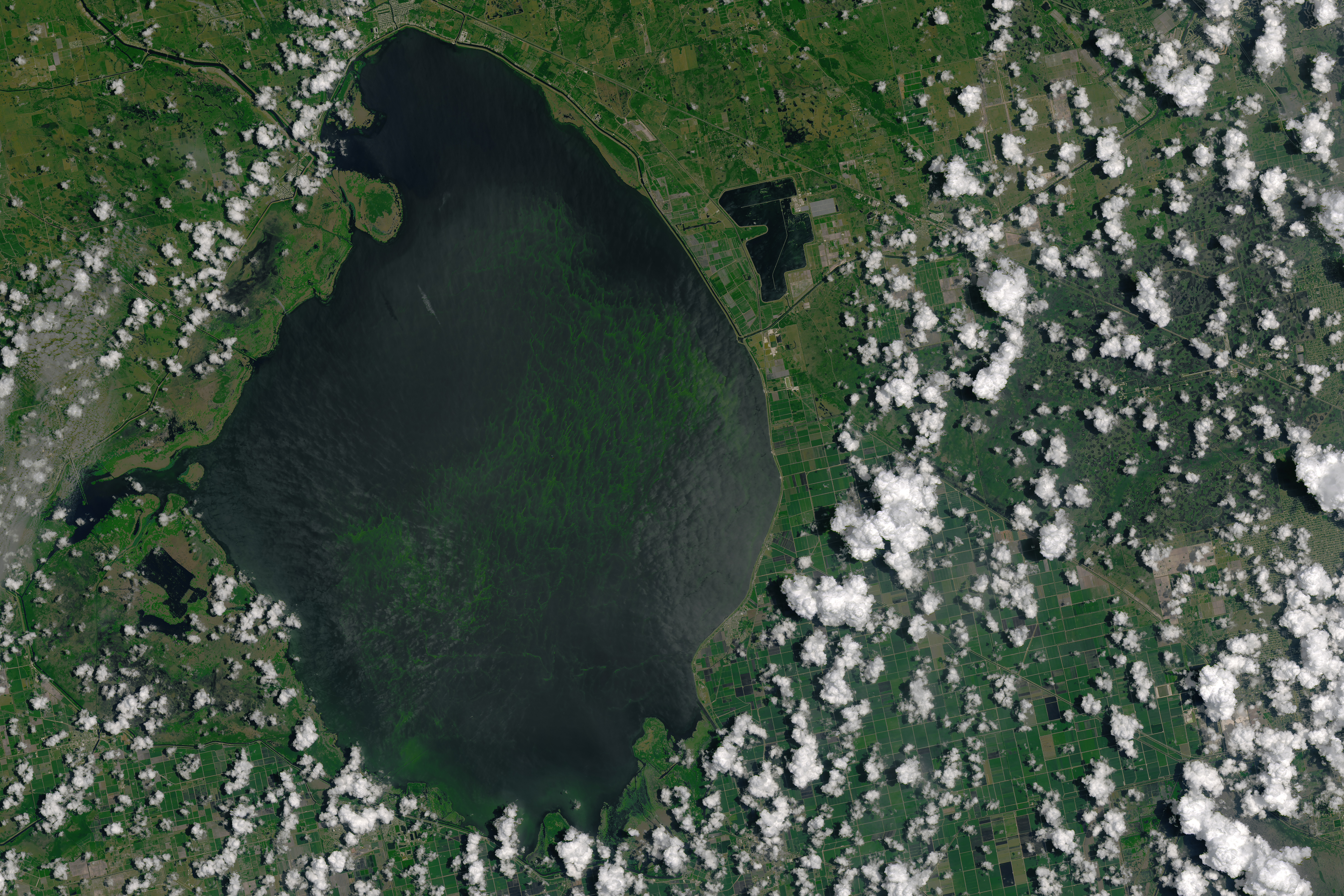
Image captured by the Landsat 8 satellite shows algae blooming on Lake Okeechobee in Florida in July 2016, when releases affected water quality in estuaries downstream. (Image credit: NASA)
Since satellites might pass a particular location once a day at best, a continuous record of high-frequency data from the SeaPRISM helps ensure that experts have a timely at-the-surface measurement to validate the satellite’s reports from orbit.
Observing waters closer to shore brings additional challenges for atmospheric correction. The turbid or eutrophic conditions more common in inland and coastal waters can scatter light in ways that frustrate some correction methods. And smoke and urban pollution interact with light differently than aerosols over the open ocean.
Harbor Branch’s experts in satellite imagery and optical sensors had that in mind as they collaborated with NASA on the agency’s PACE (Phytoplankton, Aerosol, Cloud, ocean Ecosystem) ocean color satellite mission scheduled to launch in 2024. They pitched NASA on setting up a SeaPRISM site in Florida to improve bloom detection.
Observing Harmful Algal Blooms
The Harbor Branch crew installed the SeaPRISM on a Lake Okeechobee water quality monitoring station in 2018. Lake Okeechobee is among the largest lakes in the US and the largest in Florida, making it a good candidate for satellite observations. It also suffers from harmful algal blooms of toxic cyanobacteria. The blooms can be deadly for wildlife and complicate Lake Okeechobee’s central role in the way managers move water across the state.
The Okeechobee watershed, stretching 100 miles north to Orlando, is highly channelized and quickly moves agricultural and urban runoff into the lake. Managers periodically release water to keep the lake’s level from threatening the surrounding dike that restrains it. Those releases flow west down the Caloosahatchee River to Florida’s Gulf Coast, east down the St. Lucie River to the Atlantic Coast, or south to the Everglades.
If there’s a bloom on the lake when water is released, the algae moves with it to ecologically sensitive estuaries on the coasts where it damages wildlife and algal toxins can sicken people or pets. But getting a full picture of bloom conditions on a lake as large as Okeechobee is impossible with traditional water quality monitoring methods, said Sullivan.
“You can't go around in a boat and take a million little samples to figure out what it's like,” he said. “You just don't have the manpower to do it. So, satellites allow us to get a huge coverage area.”
Harbor Branch’s work with SeaPRISM data, which is maintained and published openly by NASA, helped show how effectively atmospheric signal can be removed from satellite data from Lake Okeechobee, as well as what could be done to improve those calculations. And it wasn’t just useful for satellite validation. The sensor’s perspective of the water’s surface where cyanobacteria congregate helped detect the algae in conditions that would be too turbid for underwater chlorophyll sensors.
The next project for the Harbor Branch SeaPRISM is the Indian River Lagoon, which occupies a third of Florida’s Atlantic coast and is one of the most biodiverse estuaries in North America. The wildlife here is threatened by human impacts, including algal blooms fueled by Lake Okeechobee releases and other nutrient sources like seeping septic tanks.
The lagoon’s shallow water is a challenge for satellite observations, Moore said. The signal received by the satellite includes light reflecting from the bottom, which makes it difficult to pick out whether pigment signatures in the spectral data are coming from algae on the surface or, for example, seagrasses growing below.
“Before we can really start to use satellite data for a system like the Indian River Lagoon systematically, we have to figure this out,” Moore said. “And the SeaPRISM data will be really helpful to separate those two out.”
To continue your marine environmental research deep dive, visit: https://www.fau.edu/hboi/research/
This feature appeared in Environment, Coastal & Offshore (ECO) Magazine's 2023 Deep Dive II special edition Marine Environmental Research, to read more access the magazine here.