Monopile installation is the process of driving a tubular structure into the seabed to serve as a foundation for an offshore wind turbine. One of the key advantages of VertiCAM is its ability to perform inclination monitoring at the required accuracy and resolution without the need for physical sensors to be mounted directly onto the structure. This contactless approach eliminates the risk of sensor damage or interference during the monopile installation processes, ensuring uninterrupted monitoring throughout the operation. The offshore team can automatically determine the verticality and heading of the structure without having to pause hammering or mount any sensors to the structure.
The redundancy built into Zupt’s VertiCAM technology stems from its integration of camera and LiDAR systems, two independent solutions capable of functioning separately or together. The use of these two technologies in VertiCAM enhances its reliability, as the dual-system setup ensures continuous, accurate data collection during operations.
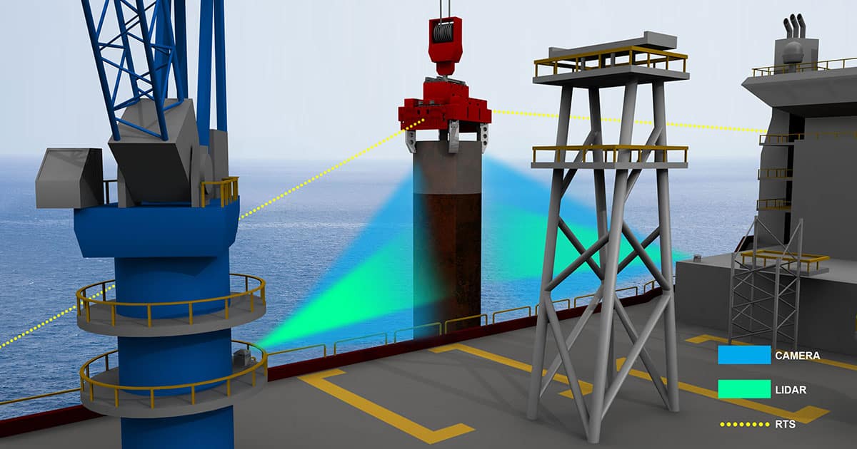
Engineered for use on construction installation vessels, VertiCAM evaluates the verticality and heading of monopiles in-air by analyzing data from LiDAR point clouds, imagery, and inertial sensors as the monopile is lowered into the seabed. It integrates two LiDAR systems, two cameras, and inertial measurement units (IMUs) at two separate “stations.” These VertiCAM stations are strategically positioned at two points on the vessel to gather data from multiple views, and these views are used to determine the pitch/roll of the monopile at various angular offsets. These stations can be mounted over 50 meters away from the installation site of the structure due to the extended range of the LiDAR. This allows for flexible deployment while still maintaining the ability to gather data from multiple views and accurately determine the verticality of the structure.
During operation, the real-time LiDAR point cloud data is quickly processed utilizing methodology such as iterative closest point matching (ICP) to determine the absolute attitude of the structure, including its verticality and heading. The IMUs integrated into VertiCAM capture inertial data, which is crucial for computing the structure’s high update rate absolute attitude, independent of the motion of the installation vessel. VertiCAM will remain accurate regardless of the installation methodology. As long as a portion of the monopile is visible, VertiCAM can effectively position it. VertiCAM is connected to an NVIDIA GPU processor running real-time verticality calculations, providing a remote human-machine interface (HMI) processor connected to the core processor via a network (ethernet) connection to allow remote data viewing and interface to the system.
Here’s how VertiCAM works:
- System Setup: Install up to three VertiCAM “stations” on the vessel to ensure redundancy, with at least one serving as a hot backup.
- Sensor Configuration: Each station is equipped with LiDAR, Cameras, IMU, and a processor.
- Installation Process: VertiCAM monitors the tubular structures pitch and roll during installation, accurately tracking its verticality. (MP only)
- Real-Time Data Processing: The LiDAR camera system detects the structure from two angles in real time. Inertial data is processed in real-time to determine the structure’s attitude independently of vessel motion.
Key Features of VertiCAM:
- Dual redundancy with LiDAR, HD Imaging Sensor, and IMU at two viewing locations.
- Contactless solution with no physical sensors to the structure.
- Real-time verticality data delivery.
- Effective operation in low visibility conditions as per ISO standards.
