")
See the iconic Cork coastline, from Bantry Bay to Roches Point, in remarkable detail thanks to a new series of maps that have been developed by INFOMAR.
From The Beara Peninsula to Mizen Head, from Cape Clear to Roaringwater Bay & Cork Harbour, these new high-resolution maps highlight the unique & intricate landscapes that lie beneath the waves.
INFOMAR (Integrated Mapping for the Sustainable Development of Ireland’s Marine Resource) has launched the Blue Scale Map Series; a collection of 18 high-resolution bathymetric maps of Ireland’s coastal waters. Developed by a dedicated team of hydrographers, data processors and cartographers, the maps highlight the topography of the coast in remarkable detail.
In 2006, the INFOMAR program was established and is currently one of the world’s largest and leading seabed mapping programs. Funded by the Department of the Environment, Climate and Communications, INFOMAR is a joint venture by the Geological Survey Ireland and the Marine Institute and aims to map Ireland’s seabed and deliver a comprehensive baseline bathymetry dataset to underpin the future management of Ireland’s marine resource.
Ireland’s coastline is approximately 3,171 km in length and boasts some of the most unique & dynamic marine environments in Europe. The Blue Scale Map Series is the culmination of over a decade of work. Each week, INFOMAR will be releasing a new map of a different section of the Irish coastline.
County Cork boasts a coastline of approximately 1,200 km—and the latest published in the new map series are the Blue Scale bathymetric maps of Bantry Bay, Mizen Head, Roaringwater Bay, Galley Head & Cork Harbour. The five maps, released on a weekly basis each Friday for the next five weeks, reveal the brilliant marine geology & unique seafloor across the Cork coastline.
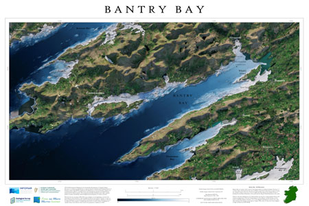
The first of the Rebel County maps is the Bluescale bathymetric map of Bantry Bay.
Bantry Bay runs approximately 35 km (22 miles) from northeast to southwest into the Atlantic Ocean. It is approximately 3 to 4 km (1.8 to 2.5 miles) wide at the head and 10 km (6.2 miles) wide at the entrance. Bantry Bay is a ria, a bay formed from a drowned river valley as a result of a relative rise in sea level. The bay is a deep (approx. 40 meters in the middle) and large natural bay, with one of the longest inlets in southwest Ireland, bordered on the north by the Beara Peninsula, which separates Bantry Bay from Kenmare Bay.
The bay has been witness to numerous shipwrecks over the years. In 1981, while cleanup efforts using sonar sweeps for the Betelgeuse were under way, the wreck of the French frigate La Surveillante, which had been scuttled during a storm north of Whiddy Island on January 2, 1797, was found. The La Surveillante has since been mapped in high resolution by INFOMAR.
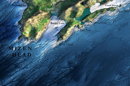
Friday 22nd September: Mizen Head
Mizen Head is traditionally regarded as the most southerly point of mainland Ireland, although Brow Head is the actual southernmost point, beating Mizen Head by only 9 meters. The headland's Irish name, Carn Uí Néid, means ‘cairn of Néid's grandson’. This refers to Balor, a leader of the Fomorians in Irish mythology.
 (Image credit: The Marine Institute)
One of the main transatlantic shipping routes passes close by to the south, and Mizen Head was, for many seafarers, the first (or last) sight of Europe. To the south, the Fastnet Rock Lighthouse, Ireland's Teardrop, was the last landfall seen by many emigrants to America and one of Marconi's first telegraph stations. Mizen Signal Station holds an important part in the history of Safety at Sea communications. In 1931 the station became home to the first Radio Beacon in Ireland. Over time, the technology at this site expanded to include Wireless Signals, Racon, GPS and DGPS.
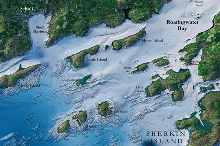
Friday 29th September: Roaringwater Bay
Roaringwater Bay is the southernmost bay in Ireland. Fastnet Rock—just to the southwest of Cape Clear Island—was known as ‘Ireland's Teardrop’ in the 19th Century, when it was the last part of Ireland that emigrants saw as they sailed to America.
 (Image credit: The Marine Institute)
Roaringwater Bay in west Cork is designated as a Special Area of Conservation (SAC) under the Habitats Directive. The marine area is designated as a large shallow inlet and bay. The bay supports a variety of sub-tidal and intertidal sedimentary and reef habitats. These include habitats that are sensitive to pressures which might arise from fishing and aquaculture, such as maerl (coralline algae), seagrass and kelp reefs.
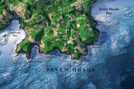
Friday 6th October: Seven Heads
The Seven Heads Peninsula, situated on the southwestern coast of Ireland, is a captivating region known for its rich maritime history and unique geology. Nestled between Clonakilty Bay and Courtmacsherry Bay, this picturesque stretch of land offers a plethora of maritime information and geological wonders.
Maritime activities have long played a significant role in the region. The peninsula's strategic location has made it an important maritime hub for centuries, witnessing trade, fishing, and maritime exploration. Its coastline is dotted with fishing villages that still retain their traditional charm, showcasing the enduring connection between the local communities and the sea.
 (Image credit: The Marine Institute)
Geologically, the Seven Heads Peninsula offers a fascinating tapestry. It boasts dramatic cliffs, rugged headlands, and hidden coves carved by the relentless power of the Atlantic Ocean. The exposed rock formations reveal the area's complex geological history, with layers dating back millions of years. From fossil-rich limestone to unique geological features, such as sea stacks and natural arches, the peninsula's geology is a treasure trove for geologists and nature enthusiasts alike.
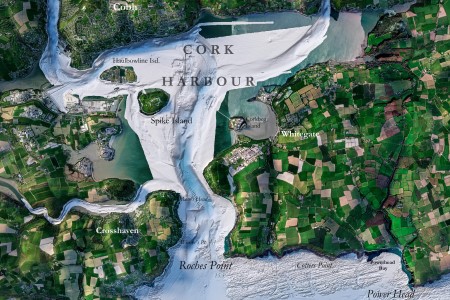
Friday 13th October: Cork Harbour
Cork Harbour is a natural harbor and river estuary at the mouth of the River Lee in County Cork, Ireland. Spike Island is centrally located within view of the mouth of the harbor and was part of a strategic military coastal defense system for the surrounding areas. The main tributary to the harbor is the River Lee which, after flowing through Cork city, passes through the upper harbor (Lough Mahon) in the northwest before passing to the west of Great Island with the main channel emerging into the lower harbor past Haulbowline Island.
 (Image credit: The Marine Institute)
For conservation and navigation purposes, the harbor is often separated into "Upper Cork Harbour" (following the River Lee from Cork city to the towns of Passage West and Monkstown) and "Lower Cork Harbour" (separated from the upper harbor by Great Island). The depth of the harbor has been measured at between 4 fathoms (7.3 m) and 14 fathoms (26 m).
Since 2006, INFOMAR’s seabed mapping efforts have been instrumental in enhancing our understanding of Ireland's underwater landscape.
 (Image credit: The Marine Institute)
The Blue Scale Map series offers a new and unique way not only to showcase the mapping effort to date, but also to visualize and communicate complex scientific information to the wider public. As with all INFOMAR data, these high-resolution maps are available for free to download and have huge potential to communicate with local coastal communities and raise awareness on the importance of maintaining the health & integrity of our marine environment.
INFOMAR is making all 18 maps available for free to the public to download in high resolution JPEG format. Follow the journey each week as a new map is released on the INFOMAR website, and join the conversation on Twitter, Instagram & Facebook.
Blue Scale Series release dates:
Friday 11th August: Galway Bay (Galway)
Friday 18th August: Loop Head (Clare)
Friday 25th August: Tralee Bay (Kerry)
Friday 1st September: Iveragh Peninsula (Kerry)
Friday 8th September: Dingle Peninsula (Kerry)
Friday 15th September: Bantry Bay (Cork)
Friday 22nd September: Mizen Head (Cork)
Friday 29th September: Roaringwater Bay (Cork)
Friday 6th October: Seven Heads (Cork)
Friday 13th October: Cork Harbour (Cork)
Friday 20th October: Youghal Bay (Cork/Waterford)
Friday 27th October: Tramore Bay (Waterford)
Friday 3rd November: Hook Head (Wexford)
Friday 10th November: Carnsore Point (Wexford)
Friday 17th November: Wicklow Head (Wicklow)
Friday 24th November: Dublin Bay (Dublin)
Friday 1st December: Donegal Bay (Donegal)
Friday 8th December: Aran Islands (Galway