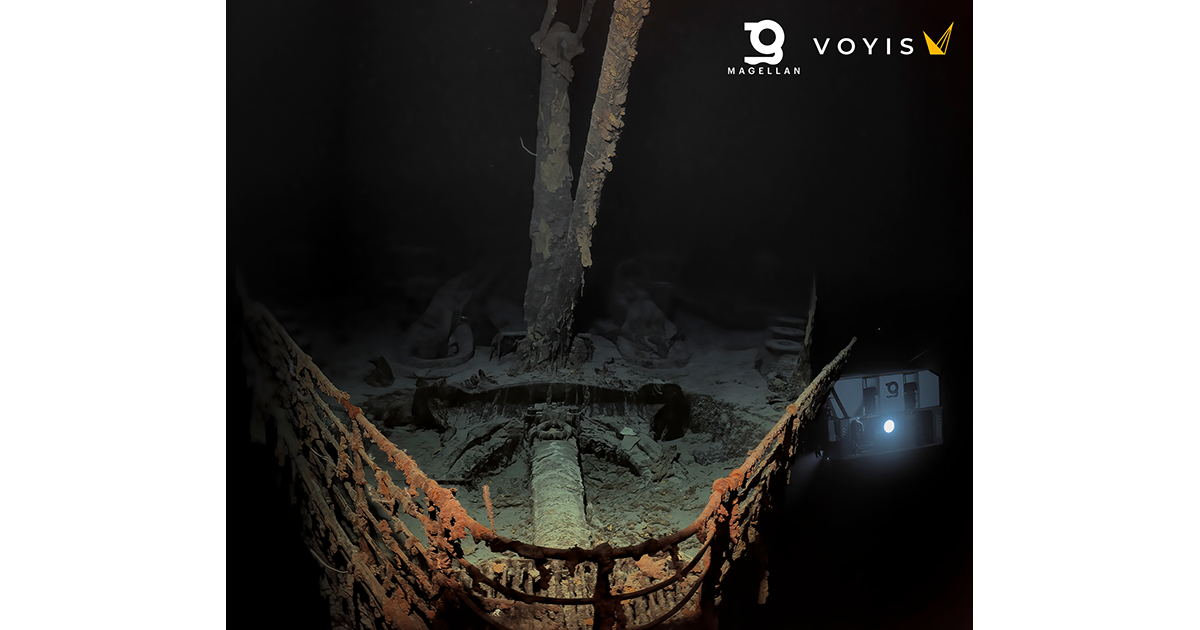
One year after Magellan’s public release of this incredible expedition, we shed some light on the making of the RMS Titanic Digital Twin.
Voyis, a leading provider of advanced underwater imaging systems in Waterloo, Canada, joined forces with subsea technology partners Sonardyne and EIVA to provide sensor systems to Magellan for their groundbreaking survey that captured the first complete Digital Twin of the RMS Titanic wreck site. This collaborative effort has resulted in an extraordinary scaled digital twin of the entire bow and stern of the famous wreck, along with the surrounding debris field, enabling researchers and scientists to start to re-explore the vessel with the greatest level of detail ever recorded. This 3D model showcases the site as if the ocean had been drained away, offering a snapshot in time of this iconic historical asset before it degrades beyond recognition (Magellan Digital Twin). The survey was completely non-intrusive thanks to Magellan’s deep water survey expertise, inhouse cameras systems, proven mapping equipment and Voyis’ long range optical systems. This offered a sustainable way to further understand the conditions of the Titanic without compromising the wreck or surrounding ecosystem.
The Titanic, resting at a depth of approximately 3,800 meters (12,500 feet) in the Atlantic Ocean off the coast of Newfoundland, Canada, has long been a subject of fascination and mystery since its tragic sinking in 1912. The aim of this ambitious project was to shed new light on the circumstances surrounding the disaster and utilize cutting-edge underwater optical technology to record the current state of this iconic wreck.
In summer 2022, Magellan Ltd, a leading deep-sea mapping and survey company, was provided with Voyis’ underwater imaging sensors to complement their own systems and conduct the extensive optical survey.
Voyis’ Observer Subsea Cameras and Nova LEDs Illuminate Every Aspect of the Wreck
Voyis provided its state-of-the-art Observer & Nova subsea imaging system in support of this endeavor. With an actively cooled high-dynamic range camera and more than ½ million lumens of flash lighting, this setup enabled the best possible color images of the wreck. Over 700,000 images were reliably captured during the multi-day survey of the region, recording millimetric details of every aspect of the site. At 3,800 m below the sea, the Observer Pro delivered clear, accurate images that were automatically corrected for both color & lighting. This delivered the image quality and consistency needed to produce Magellan’s seamless Digital Twin that you see today. This resolution and color accuracy, powered by Voyis’ proprietary True Cooler correction, has never been deployed on a wreck of this size, and was key in removing the blue and green hues that are typical in subsea optical survey. This precise visual data formed the foundation for generating the comprehensive 3D model of the entire ship, an immense processing undertaking by Magellan. Voyis is now able to release some of the color corrected original images in full resolution.
In addition to the Observer & Nova, Magellan also trialed a Voyis Insight Pro laser system to scan the wreck and debris field. The Insight Pro underwater laser scanner may provide researchers with the quantitative capability to directly measure even the smallest features. The laser model can complement the image-based Digital Twin to help further understand the rate of degradation of the historic site and measure the profile and scour on the feature-limited seabed. Voyis is also sharing limited exports from the laser model.
Critical Support from Covelya Group: Sonardyne and EIVA
Delivering fantastic images and an accurate 3D model requires more than great cameras, and trail laser scanners. Precise and accurate positioning throughout the survey is essential to ensure that complete coverage is achieved and to provide an accurate flight path for 3D model processing. As a renowned provider of innovative underwater positioning and navigation technologies, Sonardyne supplied Long BaseLine (LBL) equipment and an acoustically aided SPRINT-Nav Hybrid Navigator. Sonardyne and Magellan have worked extensively together to develop and refine these systems since Magellan invested in SPRINT-Nav across its fleet of 6k rated work class ROVs, with the result that the advanced INS/DVL/LBL technology ensured reliable and robust subsea navigation in the challenging operating conditions at the Titanic site.
Also critical to mission success is real-time feedback to the surveyors at the surface, and here EIVA, a sister company to Voyis and Sonardyne, contributed its advanced navigation and survey software capabilities to the project. EIVA’s NaviSuite software solutions facilitated the efficient collection and visualization of the vast amount of image and navigation data collected during the survey.
Unveiling New Insights into the Titanic's History
This sensor package offered to Magellan’s project by Voyis, Sonardyne, and EIVA represents a significant milestone in underwater innovation. Magellan’s unprecedented reconstruction of the Titanic has demonstrated the ability to generate incredibly accurate models of our oceans, allowing us all to see the depths like we see the surface. It is Voyis’ hope that this new technology will drive evidence-based research and a deeper understanding of not only this historic tragedy but offer tools to future explorers that unlock more of the ocean’s secrets without the need to disturb the environment. The findings from this project have the potential to reshape our knowledge of the Titanic’s sinking, bringing us closer to solving the lingering questions surrounding the event.
As leaders in their respective fields in underwater technology, Voyis, Sonardyne, and EIVA remain committed to pushing the boundaries of subsea exploration by advancing the sensors that make it all possible. By combining their technology with Magellan’s experience, deep water capability, assets and Intellectual Property, these companies have together achieved a significant milestone in underwater archaeology and ocean exploration.


