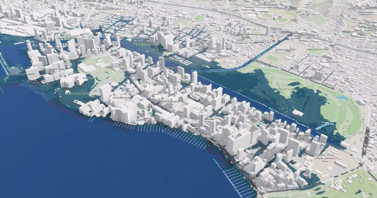
By incorporating shoreline erosion and high-wave events, in addition to rising sea levels, researchers found that current single-hazard projections overlook up to two-thirds of threatened land area on and up to 85% to 100% of critical infrastructure, such as buildings, roadways, and cesspools, that are likely to be impacted.
“This tells us that it is critical to use multiple hazard models, and that areas with little data, such as other Pacific Islands, that rely on simpler passive flood model estimates may be underestimating the risk to their coastal infrastructure,” said Anna Mikkelsen, lead author and graduate student in the Department of Earth Sciences in the UH Mānoa School of Ocean and Earth Science and Technology (SOEST).
The study updates previous sea-level rise vulnerability estimates for Oʻahu using high-resolution interagency climate projections. Researchers overlaid three advanced physical models—accounting for flooding from rising water levels, shoreline erosion, and annual high wave events—onto maps of buildings, parcels, roads, schools, hospitals, parks, wastewater infrastructure, and resident population.
An Impending Tipping Point
In addition to finding more widespread vulnerability than previously identified, the findings also emphasize that coastal impacts will not increase at a steady, linear rate. Following a steady rise in chronic nuisance flooding over the coming decades, Oʻahu faces a rapid tipping point between 2073 and 2102, depending on global emission trajectories.
“Sea-level rise will not come to Oʻahu as a slow, harmless rise in the water level,” said Chip Fletcher, senior author on the paper, Director of CRC, and dean of SOEST. “Waves and erosion are already damaging homes, roads and wastewater systems, and our results show a threshold, somewhere between 0.9 and 1.2 meters of rise, where scattered local problems become widespread infrastructure failure. Communities and government agencies need to step up planning and preparation now, while there is still time to choose how we adapt instead of reacting to each crisis as it comes.”
At the tipping point, the number of buildings affected nearly doubles, from about 5,900 to 11,100; residents affected more than double, from about 27,800 to 58,100; roads affected go from 92 km to 210 km; and sewer mains affected go from 61 km to 151 km.
Impacts to Local Infrastructure
By considering multiple factors of flooding and multiple types of infrastructure, the research team can tease apart which hazards are most likely to affect different regions on Oʻahu. For example, Honolulu will be most affected by passive and wave-driven flooding impacting the heavily built environment, and the west side is far more affected by recurring annual high-wave events and intermittent, sudden impacts. On the north shore, coastal erosion is the largest driver of impacts.
“While there are impacts to all types of infrastructure, we found that roadways and wastewater infrastructure is particularly at risk,” Mikkelsen shared. “For example, in Kaʻaʻawa, there is a 200-meter stretch of Kamehameha Highway, the only road on the east side, that will become impassable from erosion at just 0.3 meters (~1 foot) of sea-level rise, around mid-century; and on the west side, Farrington Highway, which accommodates up to ~40,000 vehicles a day with no alternate public route, starts seeing chronic impassable sections by 0.9 meters of sea-level rise.”
Around the island, there is already evidence that on-site wastewater systems such as cesspools and septic systems leach wastewater into the nearshore environment, degrading coral reefs and water quality and increasing risk of waterborne illness.
“These pathways would increase as sea levels rise because the groundwater also rises, and these systems may become flooded or unable to function properly,” Mikkelsen added. “Our study also revealed that the centralized sewer systems are at risk and will be increasingly flooded this century.”
Place-Based Adaptation Strategies
By combining coastal science, geospatial analysis, and infrastructure data, the team is providing locally relevant information to support long-term planning and help Hawaiʻi prepare for a changing coastline. The findings of this study emphasize the urgent need for tailored, place-based adaptation strategies, ranging from coastal drainage retrofits in urban Honolulu to highway connectivity and decentralized wastewater solutions for rural communities.
The study provides community-level data that county and state agencies can use for planning, and it updates the 2017 Hawaiʻi SLR Vulnerability and Adaptation Report, which UH helped produce. All hazard modeling from this open-access study is publicly accessible via the SOEST Climate Viewer.