Coastal blue carbon ecosystems (CBCEs) occupy the land–sea interface, where sea-level rise, warming, eutrophication, aquaculture, port expansion, fishing, and land-use change converge. These pressures can degrade mangroves, salt marshes, and seagrasses while also shifting where future suitable habitats may occur. Many conservation assessments remain reactive, fragmented, and blind to cumulative land–sea stressors and future expansion potential. The Kunming–Montreal Global Biodiversity Framework calls for protecting at least 30% of terrestrial and marine areas by 2030, yet planners still struggle to reconcile ecological suitability with human pressure. Based on these challenges, or because of these issues, there is an urgent need for in-depth research on integrated, proactive spatial planning for CBCEs.
Published in Environmental Science and Ecotechnology, the study was led by Beijing Normal University with collaborators from China University of Geosciences, Indiana University, and Xiamen University. The team combined maximum entropy (MaxEnt) habitat modeling, land–sea anthropogenic pressure mapping, and systematic conservation planning (SCP) with Marxan. They assessed mangroves, salt marshes, and seagrasses along China’s coast and designed spatially differentiated protection and restoration strategies. The research offers a scalable planning workflow for coastal nations.
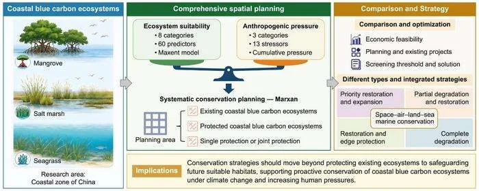
The analysis identified potential suitable distribution areas (PSDAs) of 4,188.85 km² for mangroves, 13,477.29 km² for salt marshes, and 6,255.88 km² for seagrasses—about 13-, seven-, and 24-fold increases over current extents. A clear latitudinal shift emerged: mangrove dominance in the south, salt marsh dominance in the middle, and seagrass dominance in the north, driven by temperature–salinity dynamics and sharp land–sea pressure gradients in industrial bays. Marxan optimization divided the coast into 397,961 planning units (PUs) and tested protection targets from 10% to 90%. At a 30% target, salt marshes accounted for the largest planned protected area, followed by mangroves and seagrasses. Existing nature reserves covered only about 20% of high-priority zones, leaving more than 70% of target areas dependent on active restoration. The authors classified priorities into four types: priority restoration and expansion, restoration and edge protection, partial degradation and restoration, and complete degradation. They estimated that a 30% conservation target would require about $117 billion, while annual carbon sequestration could rise by 23.25–25.87 million tons, worth roughly $2.77–3.36 billion per year.
The authors said the framework shifts blue carbon planning from reactive protection toward proactive spatial governance. They said coupling habitat suitability with cumulative human pressure helps identify where ecosystems can be restored, expanded, or defended before degradation becomes irreversible. They added that the typology-based grid strategy can help policymakers target limited funds, coordinate land and sea management, and align national actions with the Kunming–Montreal Global Biodiversity Framework. The authors said the approach is designed to adapt as climate and socioeconomic conditions change.
The framework offers a scalable model for coastal nations seeking to meet 30×30 goals while supporting climate mitigation, shoreline protection, biodiversity, and coastal livelihoods. Its grid-based categories can guide restoration finance, blue carbon markets, ecological compensation, and land–sea coordination. The authors recommend integrating satellite, airborne, land, and sea monitoring to track salinity, temperature, ecosystem health, and emerging risks in real time. They also stress that conservation planning should account for spillover effects and non-carbon ecosystem services, because carbon values alone underestimate the full socioeconomic return on protecting and restoring CBCEs. Such integrated accounting can help governments sequence restoration, avoid lock-in of high-pressure zones, and build long-term coastal resilience.