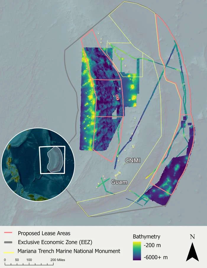
An effort of this scale and speed required cooperation between federal, industry, and nonprofit groups. In 2025, NOAA Ocean Exploration worked with NOAA’s Office of Coast Survey (Coast Survey) and NOAA Marine and Aviation Operations’ Uncrewed Systems Operation Center to support a project awarded under Coast Survey’s Hydrographic Surveys Contract Vehicle. Under this contract, contractor Woolpert used Saildrone uncrewed surface vehicles (USVs), specifically the deepwater Saildrone Surveyor platform, to fill in deep-sea mapping gaps in eastern portions of the US EEZ around CNMI and Guam. NOAA Ocean Exploration also coordinated with the US Navy to arrange the public release of mapping data from the western side of CNMI, which was collected as part of a separate, US Office of Naval Research-funded science and technology project.
The other key partner in this data-gathering initiative was Ocean Exploration Trust, a nonprofit organization that is part of the NOAA Ocean Exploration Cooperative Institute (OECI). Supported by funding from NOAA Ocean Exploration via the OECI, Ocean Exploration Trust conducted two expeditions in the US EEZ around CNMI and Guam aboard Exploration Vessel Nautilus in 2026. In addition to using E/V Nautilus‘ ROVs and newly installed mapping sonars (which received an Office of Naval Research-funded upgrade that significantly expands the ship’s mapping capabilities), these expeditions included deployments of the autonomous underwater vehicle Sentry from Woods Hole Oceanographic Institution, which was supported by funding from the Marine Minerals Administration (MMA) and included the participation of researchers from the US Geological Survey. Collectively, the 2026 E/V Nautilus expeditions to the Mariana Islands provided critical insights into the region’s deep-sea geology, habitats, and wildlife.
During two expeditions on Ocean Exploration Trust’s Exploration Vessel Nautilus, autonomous underwater vehicle Sentry from Woods Hole Oceanographic Institution was used to map and collect high-resolution imagery of the seafloor, like the image of polymetallic nodules on an abyssal plain seen here. The mapping and image data collected via Sentry serves to greatly expand the breadth of seafloor surveyed during a single expedition. Image courtesy of Larry Mayer, UNH; AUV Sentry Team; Ocean Exploration Cooperative Institute; © Woods Hole Oceanographic Institution.
These new exploration and mapping data are especially valuable and timely because MMA is preparing prospective lease sales for marine critical minerals exploration in the US EEZ around CNMI. Western parts of the EEZ have been identified as areas of interest for polymetallic sulfides, while the eastern regions may contain abyssal polymetallic nodules. Since January 2026, NOAA and partners have mapped an additional 16% of the area within the proposed lease sale areas, meaning that nearly 97% of the areas have now been mapped at high resolution. Mapping projects like these are important for learning more about the abundance of marine critical minerals in the area and enabling rigorous environmental review for any proposed exploration or commercial recovery activities.
“The power of public exploration data is that it helps everyone involved,” said Dr. Sunny Snider Centrella, NOAA Ocean Exploration’s acting director. “If you’re a US company considering an exploration lease, high-resolution maps can help you identify places to explore. If you’re a regulatory agency, the data inform potential mineral estimates and supports establishing ecological baselines. For policymakers and local communities, the public nature of this information supports responsible and transparent decision-making in the CNMI EEZ.”
In particular, Dr. Centrella said the rapid accumulation of this publicly available data highlights the importance of NOAA Ocean Exploration’s partnerships.
“No one team could operate at this scale alone. NOAA Ocean Exploration’s partnerships with industry and our Ocean Exploration Cooperative Institute members help us efficiently explore the ocean on behalf of the American public. Mapping and exploration are key priorities of the US National Ocean Mapping, Exploration and Characterization strategy (NOMEC) as well as international efforts like Seabed 2030. We’re looking forward to building on these partnerships to take ocean exploration even further.”
This mapping work supports the US Executive Order “Unleashing America’s Offshore Minerals and Resources,” which calls upon the United States federal government to advance responsible management of seabed minerals.
Mapping data from these projects in the CNMI EEZ will be publicly available via the NOAA Marine Critical Minerals (MCM) Dataset.
This article was originally published here: https://oceanexplorer.noaa.gov/news/cnmi-exploration-mapping/